


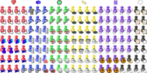
Canadian Highways Transit Map
Notes
Most road maps are complicated... this one makes Canadian highways as simple as a rail network
Transit maps tend to be topological: rather than show every twist and turn of a route, they simplify. What does it matter whether the Piccadilly Line veers left or right at Piccadilly Circus? What matters is where you change for the Bakerloo Line.
Most road maps, on the other hand, show every every zig and every zag of every highway and every street. If it's detail you want, road maps have it in abundance.
This one does not. By simplifying, you can see things you might not otherwise notice:
- Canada's curious 1-dimensionality, especially along the long, straight western border with the United States (see 1-Dimensional Countries for more examples);
- the distinct diagonal sweep of the St. Lawrence River in the east;
- the tenuous connectivity of the network: break the Central Line (er, I mean, Highway 1) between Winnipeg and Kenora, or between Thunder Bay and Nipigon, and nothing but back roads, too minor to make it onto this map, would join Canada from Atlantic to Pacific.
A word of warning: simplification is fun, but it's possible to oversimplify. You wouldn't want to use this map to navigate from Yellowknife to Niagara Falls.
Subscribe now and I’ll let you know whenever I create a new visualization
It’ll only be every couple of months or so, I won’t let anyone else have your email address, and you can unsubscribe at any time
Thanks for subscribing!
Check your inbox for an email to confirm your subscription
Oh no, something went wrong, and I was unable to subscribe you!
Please refresh your browser and try again
Date
First published 25 March 2017
Comments
Click here to leave a comment
Thanks for your comment!
I’ll check it and put it live as soon as I can
Oh no, something went wrong, and I was unable to post your comment!
Please refresh your browser and try again